Survey Services
Getting It Done Right
Bordering an average of 25 years of experience, our field crews and drafters in the office work diligently to provide accurate and timely surveys. Whether it be construction, subdivision, or legal work for title companies. We at Control Layouts take the appropriate amount of time and focus on each of our projects to give you a reliable and timely deliverable. Both in the field and the office we utilize a combination of up to date technology and blended techniques from the past. Having this combination of innovation and traditionalism we believe that Control Layouts can give YOU a great survey every time.
traditional Survey
Services
- A detailed boundary survey that is in adherence to the American Land Title Association. This kind of survey depicts the changes over time in regard to right-of-way, easements, alternate developments and other items impacting ownership of a property. This form of survey is highly useful for anyone owning a commercial property, as it helps lawyers, title agencies, and lenders assess the value of the land.
- A survey conducted in order to depict the current elevations and grades throughout a site. This form of survey is highly useful for construction, engineering and architectural firms
- A comprehensive survey used to display the boundaries of a property. This form of survey is highly valuable and in most cases required in order to conduct a sale or subdivision of a property. Insurance and legal entities will use a boundary survey to justify the extent of said lot whenever it becomes questioned.
- A complete survey that illustrates the true horizontal and vertical locations of features on a construction site. This kind of survey is required by states and municipalities in order to make sure the site is in compliance with the previously proposed & approved plans by local and state standards.
- A survey specifically designed to locate and visualize the boundary of a wetland delineation. This information is exceptionally important when looking to purchase an undeveloped lot of land. Wetland surveys help ensure that regulations are being followed and environmental risks are mitigated.
- Primarily utilized in construction, a stake-out survey is the locating of site features from an engineer plan to the construction site. Essentially making sure items such as building corners, curb sides, and much more are in accordance with the plans developed by engineers.
- The American Disabilities Act dictates that ramps entering an intersection meet certain criteria for public safety. This survey gives companies information pertaining to the slope and pitch of existing ADA ramps, in order to see if the feature is in compliance with the legislative parameters.
- Right of way is a form of easement, an easement being defined as a right to occupy or use another person’s land for a specific purpose. Easements do not give another person ownership, but merely the ability to use a part of the land for certain purposes. Some easements come in the form of drainage, right of ways, sewage, driveways etc. Our service provides either a stake out of said easement or create the legal description of a proposed easement.
- An elevation based survey that depicts the susceptibility of your household or business to flooding risks. This type of survey is essential and most of the time required when looking to obtain flood insurance.
Our Tools
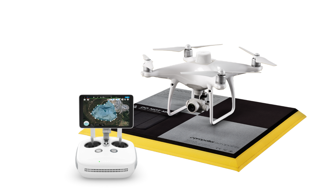
DJI Phantom 4 RTK
Propeller Aero
- The DJI Phantom 4 RTK is an impressive unmanned aircraft system with Real Time Kenimetic (RTK) capabilities. This enables us to produce 4K deliverable’s with embedded coordinates in every image.
- Propeller Aero works in tandem with the Phantom 4 RTK with its PPK network and earthworks software. Propeller’s Aero Point acts as a highly accurate ground control point, which is essential to site mapping workflows.
- The two systems bring both imagery and global navigational satellite systems together to form a fully comprehensive site plan that is accurate to the 10th of a foot.
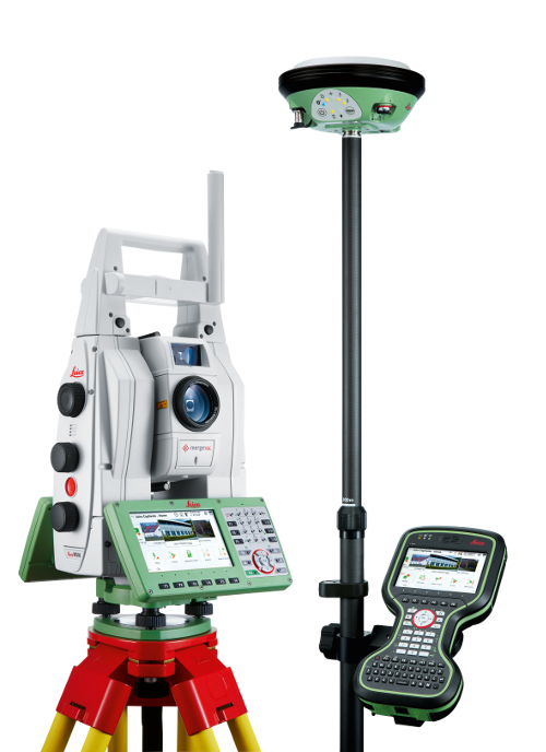
Leica Total Station & GPS
- Precision and accuracy are arguably the most important elements in land surveying. Leica meets this demand by offering cutting edge Global Navigation Satellite Systems (GNSS) and total station systems to land surveyors.
- Leica’s total stations achieve the highest levels of accuracy and reliability in measuring angles and distances. With its integrated workflows and easy of maneuverability, Leica total stations are Control Layouts equipment of choice.
- In tandem with the total station, the Leica GNSS system offers a complimentary workflow that enables us to more accurately lock into satellite coordinate systems and verify information.